Northern Ireland health board boundaries including HSE regions and hospital locations across the Republic of Ireland and Northern Ireland.
Northern Ireland health board boundaries including HSE regions and hospital locations across the Republic of Ireland and Northern Ireland.
This is our Vector Map showing the Health Regions of Ireland encompassing Northern and the Republic of Ireland(*southern Ireland). Although the health services of the to areas are completely different the boundaries are clearly shown on this map and are distinguished with lines and alternative colours for each health region. We can customise this map for you by changing the visibility of layers, adding detail such as roads and town names or supplying the editable files exactly as shown below.
Discover the Health Geography of Ireland with our digital map today, and navigate the health services of both Northern Ireland and the Republic of Ireland with ease and confidence.
Try our online Ireland Health Boundaries map colouring tool here:Customize Ireland Health Boundaries Map
Republic of Ireland Health Mapping
The Republic of Ireland has organised it’s healthcare into 6 regions. Made up of Community Health Organisations and Hospital Groups, these have been grouped into 6 larger Regions. Our map shows these regions along with the county boundaries within each region. We’ve also overlaid numbered circles to show where the hospitals are located. These are shown in a colour coded Key around the edge of the map. We’ve also included the Health Boards of Northern Ireland for completeness. Available as a vector layered illustrator map, hi-resolution raster maps or as a printed glossy laminated poster.
Health and Social Care Trusts of Northern Ireland
There are 5 trust regions in Northern Ireland which focus on planning and resourcing of services. Those boundaries are shown on our map along with the HSE Regions of the Republic of Ireland or Southern Ireland (*for search engines). The boundaries are all vector based and make up complete closed path polygons. The hospitals of Northern Ireland are also shown on this map. With the digital files, the regions can be coloured with a fill of your choosing. We’ve alse created a version of this map in our map colouring tool which is available here:
Download a free, small file bundle below, identical to our paid version.
GIS Files Sample Download
Vector Editable Graphics Files Sample Download
Raster ICB Image Files Sample Download
A Seamless Integration: North and South including hospitals.
What sets our map apart is the seamless integration of the health boundaries and hospital locations across the border, offering a holistic view of Ireland's healthcare infrastructure. This digital map serves as a bridge, connecting the North with the South, and providing a unified perspective on Ireland's health geography.

Why Choose Our Maps? Because they're all vector artwork.
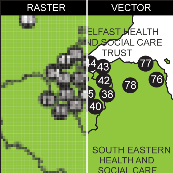
In the image below you can see an example of why vector graphics are better than raster graphics. You can see how it becomes pixelated and less clear as you zoom in on the left of the image below; this is because the map is made up of a fixed number of pixels; higher zoom levels just enlarge those pixels rather than providing more detail.
On the right, the vector map remains sharp at any zoom level. This is because it uses mathematical equations to represent map features, so it can be scaled indefinitely without any loss of quality.

Here's two reasons why vector maps, like we provide, can be considered better than raster maps:
Map Scalability: As shown, vector maps can be zoomed in on infinitely without losing detail, which is ideal for applications where users need to look at maps at varying scales.
Map Editability: Vector maps can be more easily edited to add or adjust features without degrading the quality of the map. This flexibility is crucial for customizing maps to specific user needs.
Customize your Health and Social Care Boundaries map of Northern and the Republic of Ireland online, then instantly save and download a PDF. Try it now!
We will design a map for you at very little expense. We can save you hours of messing around trying to find a map that doesn't exist.
Our custom-designed maps offer a personalized and accurate representation of NHS ICB boundaries, tailored to your specific needs. With our affordable pricing, you can gain valuable insights into healthcare trends and resource allocation, without sacrificing quality or accuracy.
Call or message us today to talk about your project. Tel 01751 473136 or Contact Form